I am very early in route planning and anything can change, I need to take out the unpaved stuff for example.
https://cycle.travel/map?from=Montpelli ... ,5.4087081
This should show the the first day and a bit of riding, I managed to navigate out of town via street view .
https://www.instantstreetview.com/@43.5 ... -26.85p,1z this shows " street view" crossing a bridge, at the very end of the bridge there are some steps to drop you on to the road below. From there the route takes you over another bridge at 90 degrees to the one just crossed, and over towards the car park to the left of the tower blocks. If I was only riding 20-30K I could just sit up and enjoy the ride, but ...in theory I could ride sections like this at 20mph, but in real terms I would be on high alert and maybe go half that speed.This would make planning a target destination difficult.
Med to Atlantic

Re: Med to Atlantic
althebike wrote:I am very early in route planning and anything can change, I need to take out the unpaved stuff for example.
https://cycle.travel/map?from=Montpelli ... ,5.4087081
This should show the the first day and a bit of riding, I managed to navigate out of town via street view .
https://www.instantstreetview.com/@43.5 ... -26.85p,1z this shows " street view" crossing a bridge, at the very end of the bridge there are some steps to drop you on to the road below. From there the route takes you over another bridge at 90 degrees to the one just crossed, and over towards the car park to the left of the tower blocks. If I was only riding 20-30K I could just sit up and enjoy the ride, but ...in theory I could ride sections like this at 20mph, but in real terms I would be on high alert and maybe go half that speed.This would make planning a target destination difficult.
So looking at the cycle travel map to start with I cycled the first 60 miles of your route 3 weeks ago. I went past Montpellier though and did the canal route to Sette through the middle of the water which was cool but bumpy and cycle travel didn't recommend it but I had put wider tyres on so I could do that sort of thing. The EV17 is reasonably marked except for in La Grand Motte which is a BIG MESS cycling wise (like its architecture) and I'd recommend just sticking to the roads-I didn't and it was horrible pavement surfaces, intermittent cycle signage and just messy. The joins in the route worked fine getting from the roads onto the canal sections into and out of Aigues Mortes- it's a marked cycle route along a canal and then very quiet road. I took the C108 from St Gilles to Arles instead of your marked route-and it was a lovely Camargue section-just me and a couple of land rovers doing camargue tours!! I spent the evening in Arles as I wanted to see some of the roman remains.
The road from Fourques is nice(r) following the cycle route marked 7 and 8, not the 17 which is a much busier road-your choice though as the 7and 8 route piddles around a bit-I think the EV17 route now follows the quieter road too but the mapping hasn't been updated. I was happy with that though as it was 36c and I wanted to be able to stop under the occasional tree and not get in the traffic (there was none-a local cyclist recommended it to me and then caught me up on his way home and we rode into Arles together).
I have cycled Ventoux and around that area several times but it's a few years ago.
Overall looking at the cycle travel route as planned I wouldn't take out any of it for being unpaved - (obviously it's up to you what type of surfaces you prefer for speed and distance etc) None of the route that it's recommending is rough to ride. I saw lots of French cyclists on skinny tyre racing bikes on these routes. I'll see what photos I have.
On that bit where you think there are steps to negotiate there aren't- I had a heavily loaded touring bike and the only portage bit I had to do on the EV17 was in Switzerland. (Disclaimer-i had to take the train for 2 days in the northern rhone due to being ill). Instead of steps you actually go under the road via a cycle route. However the bike path there at the cycle bridge was blocked there in any case when I came through so it was a road job (I cycled down to it and had to turn around). The cycle paths in that area with the exception of la grand motte are mostly pretty well thought out throughout with careful (and slightly over engineered links).
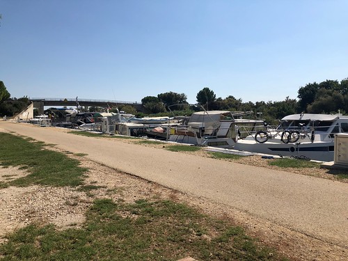 photo from roughly mile 30 on your route so you can see the surface of the canal path. The bridge you can see is where you go back onto the road at the cafe du pont.
It's not on your route but I cycled into Tarascon via a tiny road which was the route round the flood defences-it would never have occurred to me to use that if cycle.travel hadn't mapped it. Conversely cycle.travel missed out a messy section of the EV 17 and routed me onto the slightly busier road, but with an on road cycle lane, the D33 passing the village of Boulbon. I diverted and went in there for lunch and it was lovely-classic Provençal style village with a cafe for lunch in the square and boulangerie for a picnic alternative.
Re: Med to Atlantic
Mrs HJ
Thank you for your kind reply, there is a wealth of information there and I now feel much more confident being able to navigate it without undue delays. It was the lack of visual cues from street view that created the anxiety. Ventoux is the token mountain next stop calais.Regarding the steps, I could not visually see a way down to the concrete part, so I assumed steps, even though the road taking you to the bottom was only a few yards away cycle travel did not route that way.
Thank you for your kind reply, there is a wealth of information there and I now feel much more confident being able to navigate it without undue delays. It was the lack of visual cues from street view that created the anxiety. Ventoux is the token mountain next stop calais.Regarding the steps, I could not visually see a way down to the concrete part, so I assumed steps, even though the road taking you to the bottom was only a few yards away cycle travel did not route that way.
Re: Med to Atlantic
althebike wrote:https://www.instantstreetview.com/@43.547233,3.970178,72.45h,-26.85p,1z this shows " street view" crossing a bridge, at the very end of the bridge there are some steps to drop you on to the road below. From there the route takes you over another bridge at 90 degrees to the one just crossed, and over towards the car park to the left of the tower blocks.
Maybe I'm not seeing what you're seeing, but it looks to me like the cycleway is on the right of the road heading south, then crosses the road just before the roundabout and is on the left of the road heading east (where it seems to be joined by EV8 from the other roundabout island, but was under construction on Streetview earlier this year!) until you get to a gateway on the left allowing access to the canalside or a doughnut crossing to EV17.
You can follow the cycle.travel route by turning left instead after the road crossing, then right down the side road, hairpin left and then turn right onto the canalside, but that's signposted as no-vehicles. Maybe it's a former route of EV8. Also, the under-construction-this-year section isn't shown on cycle.travel's map, so it won't route you there happily.
I see no steps you'd have to use either way.
MJR, mostly pedalling 3-speed roadsters. KL+West Norfolk BUG incl social easy rides http://www.klwnbug.co.uk
All the above is CC-By-SA and no other implied copyright license to Cycle magazine.
All the above is CC-By-SA and no other implied copyright license to Cycle magazine.
Re: Med to Atlantic
althebike wrote:Mrs HJ
Thank you for your kind reply, there is a wealth of information there and I now feel much more confident being able to navigate it without undue delays. It was the lack of visual cues from street view that created the anxiety. Ventoux is the token mountain next stop calais.Regarding the steps, I could not visually see a way down to the concrete part, so I assumed steps, even though the road taking you to the bottom was only a few yards away cycle travel did not route that way.
No worries, I enjoyed interfering! I don't disagree with your premise by the way that a lot of cycle routes these days are more bitty than just getting on a road and riding. I don't mind away from the town where you can usually get a good stretch in before you move onto the next section but the towns can be infuriating on bike paths with lots of interruptions, pavement riding, random missing connections from the regional cycle planned routes (cycle.travel does fill in those gaps).
I lean towards suck it and see and I found my best approach in France where I preferred cycling the back routes was updating my broadly planned route the evening before riding it to check it, and if necessary, to fine tune it. I'm thinking of doing the same in the USA next summer as I'm not entirely sure what to expect and I'm going to give myself a few days spare for the first stage of my transam so if there are problems I can slow down and if I get it done quickly I can do more sightseeing/annoying friends stateside.
-
DSProffitt
- Posts: 6
- Joined: 30 Mar 2019, 7:44am
Re: Med to Atlantic
ConRAD wrote:SeanieG wrote:... I was wondering about the winds ...
… done it on April, never bothered as far as I remember by any type of wind !!, here some pictures, Entre-2-Mers
I dont suppose you have GPX files for this trip, do you?