Cycle Travel Question

Cycle-touring, Expeditions, Adventures, Major cycle routes NOT LeJoG (see other special board)
User avatar
Peter Molog
Posts: 95
Joined: 16 Oct 2013, 11:45am
Location: The Netherlands

Re: Cycle Travel Question

Post by Peter Molog »

Richard Fairhurst wrote:Unfortunately Google/Android has been pratting around with downloads and randomly blocking them for a few months. :(

What browser are you using, Peter? Is it Chrome, or Firefox, or Samsung Browser, or...? Does it happen on all routes, or just a particular one?

Hi Richard,
I'm using the Samsung browser. It happened with all routes. Just made a random route and tried te download. Didn't work. :evil:

But.... after installing Firefox .... it works as it should. :D

Thanks for your quick respons.

RickH wrote:And opening a saved route

A few years ago there was a period that it was necessary to save a route before you could download it, but at least on the desktop that is long gone.
Woodtourer wrote:Interseting. I just downloaded 2 routes,I have a Samsung Android Tablet, and they went to my Osmand.

?? Maybe other Android version. Or? Or?
Peter

Please, excuse my English. I'm Dutch.
User avatar
Peter Molog
Posts: 95
Joined: 16 Oct 2013, 11:45am
Location: The Netherlands

Re: Cycle Travel Question

Post by Peter Molog »

Richard,
no question, but a remark.

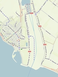
A few years ago I discovered a dry Lake of Geneva on Cycle Travel. Somehow there is now water again.
Now you're poldering in the Netherlands.
Image

Now a harbour has disappeared. :?

Location on OSM:
https://www.openstreetmap.org/#map=14/51.4460/4.0165&layers=N
Peter

Please, excuse my English. I'm Dutch.
Pendodave
Posts: 538
Joined: 3 Jun 2020, 8:27am

Re: Cycle Travel Question

Post by Pendodave »

Peter Molog wrote:
Richard Fairhurst wrote:Unfortunately Google/Android has been pratting around with downloads and randomly blocking them for a few months. :(

What browser are you using, Peter? Is it Chrome, or Firefox, or Samsung Browser, or...? Does it happen on all routes, or just a particular one?

Hi Richard,
I'm using the Samsung browser. It happened with all routes. Just made a random route and tried te download. Didn't work. :evil:

But.... after installing Firefox .... it works as it should. :D

Thanks for your quick respons.

RickH wrote:And opening a saved route

A few years ago there was a period that it was necessary to save a route before you could download it, but at least on the desktop that is long gone.
Woodtourer wrote:Interseting. I just downloaded 2 routes,I have a Samsung Android Tablet, and they went to my Osmand.

?? Maybe other Android version. Or? Or?


I use the Samsung browser and 'download' doesn't work for gpx files for me either. It's the same on different android devices running different android versions. Probably other file types as well, just haven't tried.
I get around it by copying the "gpx track link" which is displayed at the bottom of the pop up box and then pasting that into a new browser tab. It then downloads straight away without prompting. No idea why this happens, but it works so I just carry on. I then open the gpx in osmand for navigating.

Having read this thread, i tried in chrome and got a permissions prompt. I wonder if the way Samsung's browser interfaces with android permissions has anything to do with it. I don't wonder too hard though...
SA_SA_SA
Posts: 2363
Joined: 31 Oct 2009, 1:46pm

Re: Cycle Travel Question

Post by SA_SA_SA »

I wondered if the Richard F(airhurst) knew the answer to
https://forum.cyclinguk.org/viewtopic.php?f=16&t=128273&start=825#p1499972

Thanks. :D
------------You may not use this post in Cycle or other magazine ------ 8)
Richard Fairhurst
Posts: 2035
Joined: 2 Mar 2008, 4:57pm
Location: Charlbury, Oxfordshire

Re: Cycle Travel Question

Post by Richard Fairhurst »

Sorry, I've been a bit behind on the support requests! So a whole bunch at a time...

BeardyWeirdy wrote:I have quite a lot of routes now - I would like to be able to sort then on length - Some times I just only have time for a 20 mile - so I could have a quick look to see what is about of that length.

The second is that I would like to rate the route in some way and sort on that too - for example 1 to 10 as to how good they were for me - sometimes I cant remember how good or not they were, when I last rode then a few years ago. I could sort for the routes above 8 or look at the low scoring ones and rework them.


Sorting by length - no problem, have done that. I've also added a sort control to the listing on the map screen, so you can sort by name, date or distance there too.

Star ratings is an interesting idea - hadn't thought of that. I'll put it on the list though I can't promise I'll get to it immediately!

Angstrom wrote:I like the (relatively) new map base in CT named "OSM German style". It is more colorful (not an end but a means to an enhanced readability and more information)
Could it be possible to add a layer for contours and shading on that base map?


It's a third-party style so not one I can control, I'm afraid - the style decisions are all down to the OSM German community who designed the map. But I've just also added CyclOSM, which is a French bike-oriented style and which does have hill shading.

mjr wrote:Hi Richard. We're inviting people to download a West Norfolk map which uses cycle.travel's area map for the large-scale plan of King's Lynn because it's better than what we used to use. I copy-pasted the key onto it - hope that's OK.


100% fine - always happy to see the map being used!

RickH wrote:One, ever-so-minor-really, sorting issue. Being able to sort the list of entries in a folder when in map view.


Done - I've added the same sorting to the group page as I mentioned above for the main map page.

Woodtourer wrote:A question from the US!
Montana?? Started doing a route but towns are not showing.
Is this not available??


That's a curious one! So yes: cycle.travel has full map data for Montana, as it does for the rest of the US. You can ask it for (say) a route from Missoula to Billings and it'll find one fine.

But if you look on the map at a lower zoom level (small scale), you won't see many placenames. That's because OpenStreetMap (which cycle.travel uses for its data) doesn't have many places marked as a city in Montana. cycle.travel shows OSM cities at one zoom level, then towns when you zoom in more, then villages, and so on.

What I need to do is make that judgment more nuanced in areas where there aren't many cities, so maybe it would show you towns in Montana at the level that it shows cities in the UK. That way, the map would have a more even density. But it's a hard problem to solve.

SA_SA_SA wrote:Is there a way of making OSMAND offline maps look like cycle travel
(why/how do cycle travel maps look different from OSM maps?)


That's more of an OSMand question than a cycle.travel question really. I think (I'm not that familiar with OSMand) the answer is yes, ish, but only if you're prepared to do a lot of very techy work - the details are here: https://osmand.net/help/docs/Custom_Ren ... How-To.htm . Even then you'd miss out on quite a lot of cycle.travel's nuances, like the differences in styling for urban and rural areas.

The reason why the maps look different is (summarising greatly!) that cycle.travel has several hundred lines of rendering code to make the maps look the way I like them, whereas OSMand has several hundred lines of different rendering code to make the maps look the way that they like them. I need to get on and finish the cycle.travel mobile app really!

Peter Molog wrote:Richard,
no question, but a remark.

A few years ago I discovered a dry Lake of Geneva on Cycle Travel. Somehow there is now water again.
Now you're poldering in the Netherlands.
Image

Now a harbour has disappeared. :?

Location on OSM:
https://www.openstreetmap.org/#map=14/51.4460/4.0165&layers=N


Ah, I see. OSM coastlines are updated at a different pace to the rest of OSM (...it's a long story), so if the coastline is modified - as it has been in this case - it's possible for the coastline to get out of sync with the rest of the map. I'll look into doing a coastline update next time I update the map.
cycle.travel - maps, journey-planner, route guides and city guides
Richard Fairhurst
Posts: 2035
Joined: 2 Mar 2008, 4:57pm
Location: Charlbury, Oxfordshire

Re: Cycle Travel Question

Post by Richard Fairhurst »

And something new entirely...

I've added a route browser page: https://cycle.travel/browse

This highlights cycle.travel's touring route guides, plus (most) other UK National Cycle Network routes, for which I've written short summaries. You can click on a route to see the summary, then open it in the route-planner for you to edit, download a GPX, etc. etc. That means that (say) if you want to ride NCN 1, you can get a route instantly without having to set a hundred via points yourself.

I'll be adding more non-UK routes to this in coming weeks, starting with France.
cycle.travel - maps, journey-planner, route guides and city guides
richardfm
Posts: 972
Joined: 15 Apr 2018, 3:17pm
Location: Cardiff, Wales

Re: Cycle Travel Question

Post by richardfm »

Richard Fairhurst wrote:And something new entirely...

I've added a route browser page: https://cycle.travel/browse

This highlights cycle.travel's touring route guides, plus (most) other UK National Cycle Network routes, for which I've written short summaries. You can click on a route to see the summary, then open it in the route-planner for you to edit, download a GPX, etc. etc. That means that (say) if you want to ride NCN 1, you can get a route instantly without having to set a hundred via points yourself.

I'll be adding more non-UK routes to this in coming weeks, starting with France.

I like that, thank you Richard
Richard M
Cardiff
doodah
Posts: 164
Joined: 9 Aug 2008, 2:26pm

Re: Cycle Travel Question

Post by doodah »

Perhaps I have missed this - so apologies if it has been previously posted.

Looking at the elevation of a route on CT, it is now shaded orange - amber - red.

What do these indicate please? An increase in gradient?

Thank you

Doodah
Richard Fairhurst
Posts: 2035
Joined: 2 Mar 2008, 4:57pm
Location: Charlbury, Oxfordshire

Re: Cycle Travel Question

Post by Richard Fairhurst »

It hasn't been previously posted because it's only just gone live! :D

Yes, they highlight the steepest gradients of a route. (Amber is 3.5%-7%, red is 7%-10.5%, maroon is 10.5%+.) It works best on shorter routes as the highlights tend to become very narrow on a longer route.

At the same time, the total ascent/descent calculation is now more accurate than it used to be.
cycle.travel - maps, journey-planner, route guides and city guides
doodah
Posts: 164
Joined: 9 Aug 2008, 2:26pm

Re: Cycle Travel Question

Post by doodah »

What speedy service.

Any chance of you working behind the bar at my local?

Cheers

Doodah
st599_uk
Posts: 1107
Joined: 4 Nov 2018, 8:59pm

Re: Cycle Travel Question

Post by st599_uk »

Just wondering if there's an official way of planning multiday tours?

It would be good to be able to view an overview of the whole route and a route PDF and be able to download daily GPX files. Also adding pins for sightseeing or similar.

Would be great to be able to view an entire folders GPX routes in one and print a single PDF.
A novice learning...
“the dreamers of the day are dangerous men, for they may act their dreams with open eyes, to make it possible.”
Richard Fairhurst
Posts: 2035
Joined: 2 Mar 2008, 4:57pm
Location: Charlbury, Oxfordshire

Re: Cycle Travel Question

Post by Richard Fairhurst »

Not yet - it's something I'm definitely looking at but haven't quite hit on the right way of doing it yet. But there are a few things you can do:

  • You can split a long route into several shorter routes. Open the long route, right-click the via point you want to start at, and choose "Delete before". Then right-click the via point you want to end at, and choose "Delete after". (Command-click if you're on a Mac without a right mouse button.) Save the route under a new name. Repeat for each day.
  • You can add an annotation for any via point. Click the via point and choose "Edit", then type your text. Annotated via points appear in dark red rather than blue.
  • You can of course see all the routes in a folder at the same time - go to 'My bike' and then 'Journeys', and click 'Map' next to the folder name.
cycle.travel - maps, journey-planner, route guides and city guides
User avatar
Sweep
Posts: 8448
Joined: 20 Oct 2011, 4:57pm
Location: London

Re: Cycle Travel Question

Post by Sweep »

Dangerous warning

Downloaded a route a day or two ago - all fine.
Just tried to download a route to my chromebook, chrome browser, and been told that for my own protection the download was blocked.

This from the chromebooks help info:

@@@

Google Chrome blocks downloads
Chrome automatically blocks harmful downloads that try to cause problems on your computer, like:

Giving you viruses
Leaking your private data
Changing your browser and computer settings
Adding unwanted extensions or toolbars to your browser
Why the download was blocked
Your file download may have been blocked for one of two reasons:

We think it might be a malicious, unwanted, or uncommon file.
Malicious: You tried downloading malware.
Unwanted: You tried downloading a deceptive piece of software. This program, disguised as a helpful download, may actually make unexpected changes to your computer.
Uncommon: You tried downloading an unfamiliar and potentially dangerous piece of software.
We've found that the website you tried to download the file from has been known to distribute malware.

@@

Have no idea what that's all about - as I say fine the other day, always been fine.

No warnings about the web page at all - just when I trued to download the gpx

edit - more info.

One of my attempts to download does seem to have downloaded something that at first site in a text editor does look like a gpx file, though, very oddly, though the file would normally, from memory, be called something like cycletravel.gpx, it has the very odd name: Unconfirmed 573648.crdownload
Sweep
User avatar
Paulatic
Posts: 7824
Joined: 2 Feb 2014, 1:03pm
Location: 24 Hours from Lands End

Re: Cycle Travel Question

Post by Paulatic »

Sweep wrote:Dangerous warning

Downloaded a route a day or two ago - all fine.
Just tried to download a route to my chromebook, chrome browser, and been told that for my own protection the download was blocked.

This from the chromebooks help info:

@@@

Google Chrome blocks downloads
Chrome automatically blocks harmful downloads that try to cause problems on your computer, like:

Giving you viruses
Leaking your private data
Changing your browser and computer settings
Adding unwanted extensions or toolbars to your browser
Why the download was blocked
Your file download may have been blocked for one of two reasons:

We think it might be a malicious, unwanted, or uncommon file.
Malicious: You tried downloading malware.
Unwanted: You tried downloading a deceptive piece of software. This program, disguised as a helpful download, may actually make unexpected changes to your computer.
Uncommon: You tried downloading an unfamiliar and potentially dangerous piece of software.
We've found that the website you tried to download the file from has been known to distribute malware.

@@

Have no idea what that's all about - as I say fine the other day, always been fine.

No warnings about the web page at all - just when I trued to download the gpx

edit - more info.

One of my attempts to download does seem to have downloaded something that at first site in a text editor does look like a gpx file, though, very oddly, though the file would normally, from memory, be called something like cycletravel.gpx, it has the very odd name: Unconfirmed 573648.crdownload


Go back to May 2019 in this thread and it might be the answer.
Whatever I am, wherever I am, this is me. This is my life

https://stcleve.wordpress.com/category/lejog/
E2E info
User avatar
Sweep
Posts: 8448
Joined: 20 Oct 2011, 4:57pm
Location: London

Re: Cycle Travel Question

Post by Sweep »

thanks - will tinker.
Sweep
Post Reply