Where you see a "thou shalt not" like that, it's usually because something has been mistakenly marked in OSM as a private road, a one-way road, a banned turn, or something like that. In this case it's a one-way road - the whole of the slip road (near Tesco Extra) has been marked as one-way, whereas the bit from the T-junction to the start of the cycleway should actually be two-way, at least for bikes. (Often you can find the cause of these things in cycle.travel by dragging the end-point until the problem goes away, at which point you know where the issue is!)
Probably the best tutorial for OSM is just to register an account and start editing: there's a really useful walk-through that shows you how it all works.
JakobW - a PDF for the turn-by-turn instructions is a good idea: I'll give that some thought.
Cycle Travel Question
-
Richard Fairhurst
- Posts: 2035
- Joined: 2 Mar 2008, 4:57pm
- Location: Charlbury, Oxfordshire
Re: New Route Planner
cycle.travel - maps, journey-planner, route guides and city guides

Re: New Route Planner
Richard Fairhurst wrote:Wow - there's something I've never seen before. Someone has added no-right-turn and no-left-turn restrictions from the road to the cyclepath, suggesting that turning onto the path there is actually banned. That seems vanishingly unlikely to me - do you know if it's the case on the ground?
(All of this, of course, is the point of OSM - "given enough eyeballs, all bugs are shallow"!)
Yes I see the problem now, thanks. There are no turn restrictions (either signed or physical) & I have edited the map accordingly. I deleted the turn restrictions there & the same again north of the Ship Canal where there was also a restriction preventing routing back onto the (newly resurfaced) towpath when it reappears. Cycle.travel will route off the towpath onto the road but not the other way. Hopefully once the maps are next updated the routing will be correct.
Former member of the Cult of the Polystyrene Head Carbuncle.
Re: New Route Planner
Richard Fairhurst wrote:...JakobW - a PDF for the turn-by-turn instructions is a good idea: I'll give that some thought.
Until then microsoft and linux have print to pdf which is what I do for Turn by Turn.
NB after a real life experiment, I find manually writing Turn by Turn numbers onto the maps very useful. A pity it is hard to do automatically.
NB for some multi map pdfs I discovered some of the maps printed as thin lines rather than copy of screen (pdf maps always used to print as this for me till fixed (or mainly fixed a sit now seems).
The 1st map of a set was always OK.
Thanks for the useful website
------------You may not use this post in Cycle or other magazine ------ 
-
Richard Fairhurst
- Posts: 2035
- Joined: 2 Mar 2008, 4:57pm
- Location: Charlbury, Oxfordshire
Re: New Route Planner
Just added Hungary and Slovakia routing and mapping to cycle.travel. For the medium term, I've also started work on a technical change that should allow still more countries to be added easily.
On the PDF maps, I've improved the logic behind choosing the map 'panels' a little, and also added a number in the corner of each panel so you can follow the flow more easily.
On the PDF maps, I've improved the logic behind choosing the map 'panels' a little, and also added a number in the corner of each panel so you can follow the flow more easily.
cycle.travel - maps, journey-planner, route guides and city guides
-
Woodtourer
- Posts: 354
- Joined: 23 Jan 2018, 1:51pm
Re: New Route Planner
Oh great! Now I have more places to tour!!
-
Woodtourer
- Posts: 354
- Joined: 23 Jan 2018, 1:51pm
Re: New Route Planner
Today my wife and I were doing a bit more of or route planning for our upcoming European tour. Once again we are very pleased with this new to us route planner!! I was able to download our routes to a PDF on my tablet and by using the "Tour" setting I am quite pleased with the details.
Thanks again for your labor of love!!!
Thanks again for your labor of love!!!
Re: New Route Planner
Richard Fairhurst wrote:JakobW - a PDF for the turn-by-turn instructions is a good idea: I'll give that some thought.
I'm not JakobW but I just wanted this or something similar again. Copy-pasting the turn-by-turn and doing search-and-replace to make it into a route card is tedious. I'd like a way to make https://cycle.travel/map/journey/22446 into something like "Follow cycleway [1] 300m Enter King's Lynn 1100m Cross Road 600m L (minor road [1]) 130m R (cycleway [1]) 800m L 600m L 400m R 200m L (Priory Lane [1]) 1000m Ling Common Road 1000m L (Lynn Road [1]) 700m Enter Castle Rising 150m L (Hospital Lane [1]) 1mi SO (cycleway [1]) 900m Cross Road 40m R (Cat's Bottom Road [1]) 1.9mi" and so on...
MJR, mostly pedalling 3-speed roadsters. KL+West Norfolk BUG incl social easy rides http://www.klwnbug.co.uk
All the above is CC-By-SA and no other implied copyright license to Cycle magazine.
All the above is CC-By-SA and no other implied copyright license to Cycle magazine.
Re: New Route Planner
I don't get this. What are all the [1] in your list for? And what's wrong with printing out the turn by turn instructions as they are? I haven't tried this – I always print out the map or download the gpx – so perhaps there's a problem I'm not aware of, but as a set of instructions it looks pretty clear to me.
Re: New Route Planner
Bmblbzzz wrote:I don't get this. What are all the [1] in your list for? And what's wrong with printing out the turn by turn instructions as they are?
The [1] are the route 1 numbers, a crude typed representation of the number in the coloured box, very useful info.
What's wrong with printing out the turn by turn instructions as they are is that they don't fit in many map pockets because they're too big for most reasonable length rides.
MJR, mostly pedalling 3-speed roadsters. KL+West Norfolk BUG incl social easy rides http://www.klwnbug.co.uk
All the above is CC-By-SA and no other implied copyright license to Cycle magazine.
All the above is CC-By-SA and no other implied copyright license to Cycle magazine.
Re: New Route Planner
Route numbers would be a useful bit of information to include, where they apply, but as far as I can see they're there already. It looks as if they could usefully be made more prominent on the printed version.
IIUC you seem to think there is too much info in the pdf as it is? At least I assume that because you've removed some for your version. Personally, I'd find the version with one instruction per line easier to follow; but I don't think this proves anything except that you can only please some people.
IIUC you seem to think there is too much info in the pdf as it is? At least I assume that because you've removed some for your version. Personally, I'd find the version with one instruction per line easier to follow; but I don't think this proves anything except that you can only please some people.
Re: New Route Planner
Bmblbzzz wrote:IIUC you seem to think there is too much info in the pdf as it is?
Yes, or rather that the representation is too big. A simple 50 mile ride shouldn't be 4 pages of A4.
MJR, mostly pedalling 3-speed roadsters. KL+West Norfolk BUG incl social easy rides http://www.klwnbug.co.uk
All the above is CC-By-SA and no other implied copyright license to Cycle magazine.
All the above is CC-By-SA and no other implied copyright license to Cycle magazine.
Re: New Route Planner
A 200km audax will typically have a 2-page routesheet. But that's double columns, so effectively the same as 4 pages printed out one instruction per line, and using various abbreviations and symbols, so "Cross major road" will be "SO @ X" and "Turn left onto minor road" will be reduced to three characters "L @ T". That's great for conciseness but means you have to learn the symbols and abbreviations; not appropriate for a route planning site that aims to be open and accessible to everyone, and which will probably be used by visitors from abroad who might find abbreviations baffling. And an audax will typically use longer sections of main road than a cycle.travel route, again reducing the number of instructions per mile. So I'm not that surprised a 50 mile ride printed one instruction per line takes 4 pages of A4. But as I said, I've always printed out the map instead.

Re: New Route Planner
Audax rides can be very different from cycle.travel routes. I remember one (in the UK) that had 3 functional instructions for 123 km
R from Control
40 km: R at T
18 km: Control on R
R from control
800m: R at T (it's a roundabout now)
60km: 1st exit at RAB
4.3 km: Control on R
R from Control
40 km: R at T
18 km: Control on R
R from control
800m: R at T (it's a roundabout now)
60km: 1st exit at RAB
4.3 km: Control on R
-
Richard Fairhurst
- Posts: 2035
- Joined: 2 Mar 2008, 4:57pm
- Location: Charlbury, Oxfordshire
Re: New Route Planner
Ok, as requested... cue-sheets!
They look like this:
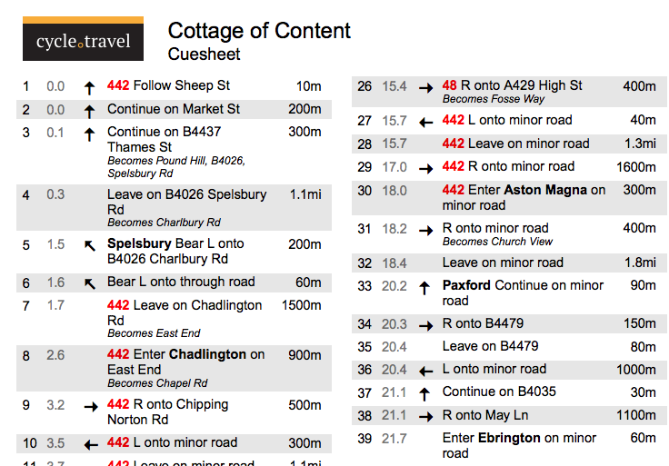
I've tried to strike a middle ground between "concise" and "don't require a course to understand them". As @andrew_s says, cycle.travel routes aren't exactly Audax routes anyway so the ultra-concise style wouldn't really be appropriate. @mjr's route comes out as three columns which seems reasonable to me.
To download one, just save the route as usual, click the PDF button, and select the new 'Cue-sheet' option.
They look like this:
I've tried to strike a middle ground between "concise" and "don't require a course to understand them". As @andrew_s says, cycle.travel routes aren't exactly Audax routes anyway so the ultra-concise style wouldn't really be appropriate. @mjr's route comes out as three columns which seems reasonable to me.
To download one, just save the route as usual, click the PDF button, and select the new 'Cue-sheet' option.
cycle.travel - maps, journey-planner, route guides and city guides
Re: New Route Planner
I reckon they're fairly clear. I might even try using one some day! Until then, let my first sentence be understood in a purely impressionistic sense.