Planning trip and route for end of May 2016
Re: Planning trip and route for end of May 2016
Here is day one. I will get the ferry across from Pastow and then cycle on the coast road to Tintagel.
Somebody said that the A3072 to Newquay is a bad road to cycle on, however the next road across is the A30 and to go any further South appears to be too far out of the way. I don't particularly want to go via Newquay but I cant see any better way to get to Tintagel.
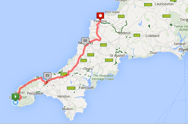
Lastly, there is the odd point on Days 1 & 2 where I have to cross the A30, and on a map it looks like you have to ride a very short section of it, presumably this is possible with the current ban on cyclists using the A30?
Re: Planning trip and route for end of May 2016
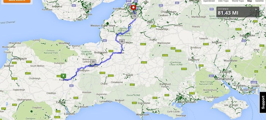
Tiverton to Bristol - looks like a long day but just under 3000ft climbing. I want to go through cheddar gorge so that's what is adding the elevation.
I have a YHA booked in . Bristol but I wouldn't mind maybe looking for somewhere better. I want it to be in a similar location though as I have a long day up to Shrewsbury the next day.
I have concerns over how secure my bike and all my kit will be in a YHA having not stayed in one before - with my iphone, garmin, lights etc. all needing to be on charge etc.
Route:
Does anyone know what the green dots on the mapmyride maps signify?
I have a YHA booked in . Bristol but I wouldn't mind maybe looking for somewhere better. I want it to be in a similar location though as I have a long day up to Shrewsbury the next day.
I have concerns over how secure my bike and all my kit will be in a YHA having not stayed in one before - with my iphone, garmin, lights etc. all needing to be on charge etc.
Route:

Does anyone know what the green dots on the mapmyride maps signify?
Re: Planning trip and route for end of May 2016
I've never had a problem with the main roads round Newquay.Emonda wrote:Somebody said that the A3072 to Newquay is a bad road to cycle on, however the next road across is the A30 and to go any further South appears to be too far out of the way. I don't particularly want to go via Newquay but I cant see any better way to get to Tintagel.
To get to Tintagel an NOT go via Newquay is ok I reckon.
You should be able to pick the bits out of this map to do it.
You need to go up the A3075 to Goonhavern, then St Newlyn East, Gummow's Shop and St Columb Major, then work your way onto Padstow. I've cycled all those roads a few times.
No problems where you are.Emonda wrote:there is the odd point on Days 1 & 2 where I have to cross the A30, and on a map it looks like you have to ride a very short section of it, presumably this is possible with the current ban on cyclists using the A30?
The ban is over Bodmin Moor from the Bodmin turn-off, to the other side of Temple towards Bolventor.
Mick F. Cornwall
Re: Planning trip and route for end of May 2016
ok - next 2 days:
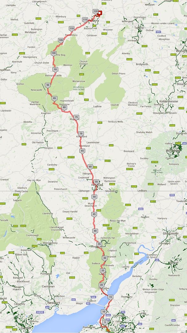
Bristol to Shrewsbury - this is going to be a fairly hard day but should be more rolling hills than Devon and Cornwall
121 miles
6875 ft elevation
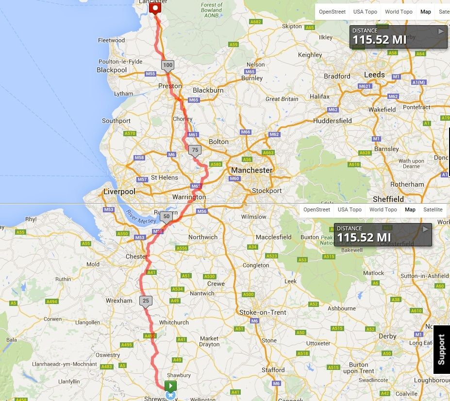
Shrewsbury to Lancaster - shouldn't be too hard - just conscious that this goes through so many towns and industrialised areas - I am used to these types of roads so not overly concerned - but it is different to the majority of roads on this tour. I presume people consider this stage a necessary evil
115 miles
2825 ft elevation
Any comments on either of these routes?
I tested my loaded Apidura saddle bag and Garmin both for the first time this weekend on a 2 day mini tour or around 130 miles. Learnt two important lessons - I need to travel MUCH lighter and I need to ensure that my GPX routes are carefully plotted - it kept trying to take me onto unpaved roads and I would have to navigate around these (normally resorting to using maps on my phone) before I could rejoin my original route - not good.
Bristol to Shrewsbury - this is going to be a fairly hard day but should be more rolling hills than Devon and Cornwall
121 miles
6875 ft elevation

Shrewsbury to Lancaster - shouldn't be too hard - just conscious that this goes through so many towns and industrialised areas - I am used to these types of roads so not overly concerned - but it is different to the majority of roads on this tour. I presume people consider this stage a necessary evil
115 miles
2825 ft elevation

Any comments on either of these routes?
I tested my loaded Apidura saddle bag and Garmin both for the first time this weekend on a 2 day mini tour or around 130 miles. Learnt two important lessons - I need to travel MUCH lighter and I need to ensure that my GPX routes are carefully plotted - it kept trying to take me onto unpaved roads and I would have to navigate around these (normally resorting to using maps on my phone) before I could rejoin my original route - not good.
Re: Planning trip and route for end of May 2016
Finally plotted every day. I wont bother posting screenshots because after Bristol my navigation basically just follows the Nick Mitchell book route.
Total mileage is 982
Total elevation is 49,076
= 49.97 ft per mile which I believe is the norm.
One question - as I will be on a road bike with 23 or 25mm tyres I have been doing a bit of research into the canal paths around Fort William etc. and will probably decide on the day if I think they are worth taling.
However, whilst there is a lot of talk on this section, what is the paving like on these two cycle paths:
NCN75 throughout Glasgow
NCN1 from Inverness all the way practically to the Crask Inn
Thanks,
-
hilloverthehill
- Posts: 38
- Joined: 9 May 2016, 11:14am
- Contact:
Re: Planning trip and route for end of May 2016
Hi I completed a JOGLE in November, mainly camping and off road/back roads where possible. It looks like you've planned a lot of your route, but if you're open to suggestions you could have a look at my blog http://hilloverthehill.blogspot.co.uk I managed to avoid the central belt of Scotland by heading across to Isle of Arran. There's quite a lot of off-road trails though Ayrshire, and really quiet back roads around west side of Loch Awe, and a lovely cycle trail from near Oban to Ballachulish. There are some roads you definitely want to avoid, such as the A road up the west side of Loch Ness. Have a great ride!
Re: Planning trip and route for end of May 2016
Please can somebody advise on the cycle routes below please?
Thanks
Emonda wrote:
One question - as I will be on a road bike with 23 or 25mm tyres I have been doing a bit of research into the canal paths around Fort William etc. and will probably decide on the day if I think they are worth taling.
However, whilst there is a lot of talk on this section, what is the paving like on these two cycle paths:
NCN75 throughout Glasgow
NCN1 from Inverness all the way practically to the Crask Inn
Thanks,
Thanks