(You will be surprised to know)
Hills vs Flat
Re: Hills vs Flat
I was running out of gears pretty quick.
(You will be surprised to know)
(You will be surprised to know)

Re: Hills vs Flat
The lower limit to gearing is when you can't stay upright any longer. The 34x32 (chainring x sprocket) position on my compact just about does it for me, since my diabetes-afflicted sense of balance isn't great. The 26x34 on my LHT was simply lethal.
This may be some help:
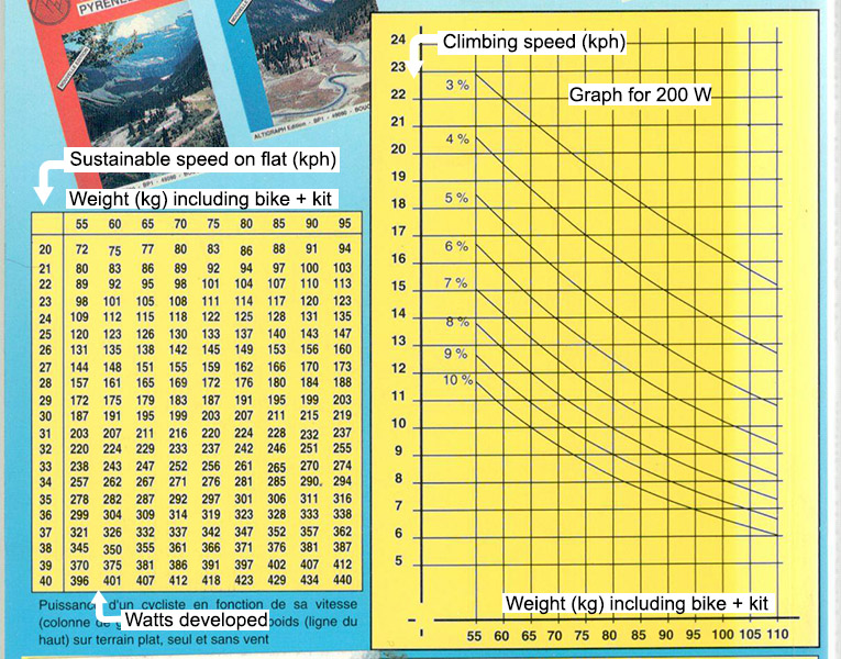
Use the LH table to establish your sustainable wattage (alone, on the flat, and without wind (fat hope)). The set of curves on the right shows climbing speed vs total weight for sustainable power of 200 Watts. Expect more or less accordingly.
In 2007 I did a 1000k Audax and next day climbed the 2000-metre Tourmalet with a vertical climbing speed of 9 metres / minute. This last Sunday I climbed the 570-metre Col du Schaentzel at 8.4 metres/minute, after an approach ride of 30 km, and today I'm still knackered. Must be getting old.
This may be some help:
Use the LH table to establish your sustainable wattage (alone, on the flat, and without wind (fat hope)). The set of curves on the right shows climbing speed vs total weight for sustainable power of 200 Watts. Expect more or less accordingly.
In 2007 I did a 1000k Audax and next day climbed the 2000-metre Tourmalet with a vertical climbing speed of 9 metres / minute. This last Sunday I climbed the 570-metre Col du Schaentzel at 8.4 metres/minute, after an approach ride of 30 km, and today I'm still knackered. Must be getting old.
Have we got time for another cuppa?
Re: Hills vs Flat
Thanks for that, but the metric info and climbing per minute means little or nothing to me. 
9mtrs per minute eh?
I climb Gunnislake Hill from the village to the top of the steep bit in .............. I have to calculate this from my stats ............
I do this ride about one out of two rides. I tend to alternate up Gunny Hill with up Gulworthy Hill (less steep, but much longer)
627 seconds to climb 409ft from the village to the top of the steep section of Gunny Hill ............. and this is on the Moulton.
That's 10.45 minutes to climb 124.66 metres
Therefore, I climb at 11.9 metres per minute.
Easy peasey.
I'll race you any time, and I'm 65 in a few months.
Mick F. Cornwall
Re: Hills vs Flat
Mick F wrote:9mtrs per minute eh?
...
I'll race you any time, and I'm 65 in a few months.
You don't have diabetes, though. Honestly, you men!

Re: Hills vs Flat
LollyKat wrote:Mick F wrote:9mtrs per minute eh?
...
I'll race you any time, and I'm 65 in a few months.
You don't have diabetes, though. Honestly, you men!
Think Mick has a terminal case of BAD - not alone on here!
Oh BAD - Bike Addiction Disorder
Convention? what's that then?
Airnimal Chameleon touring, Orbit Pro hack, Orbit Photon audax, Focus Mares AX tour, Peugeot Carbon sportive, Owen Blower vintage race - all running Tulio's finest!
Airnimal Chameleon touring, Orbit Pro hack, Orbit Photon audax, Focus Mares AX tour, Peugeot Carbon sportive, Owen Blower vintage race - all running Tulio's finest!
Re: Hills vs Flat
Grarea wrote:I have just been playing with numbers on that chart.
I was wondering about the gradient of the hills I cycle on.
Is there an accurate way to measure them?
I think there are these things with yellow tripods and scales that people use
MJR, mostly pedalling 3-speed roadsters. KL+West Norfolk BUG incl social easy rides http://www.klwnbug.co.uk
All the above is CC-By-SA and no other implied copyright license to Cycle magazine.
All the above is CC-By-SA and no other implied copyright license to Cycle magazine.
Re: Hills vs Flat
Nothing is 100% accurate when it comes to gradient (except perhaps measuring it, like mjr suggested  ), but you can pop any route into something like MapMyRide and it will give you elevations at any point on the route, then you can calculate the gradient between two points. http://www.mapmyride.com/ I think you can get a rating (category) for any of your climbs over 500 m long and 3% gradient. I don't use that function, so I don't know how it works.
There are some other sites that do similar things. Some might do the gradient calculation for you.
There are some other sites that do similar things. Some might do the gradient calculation for you.
“In some ways, it is easier to be a dissident, for then one is without responsibility.”
― Nelson Mandela, Long Walk to Freedom
― Nelson Mandela, Long Walk to Freedom
Re: Hills vs Flat
mjr wrote:Grarea wrote:I have just been playing with numbers on that chart.
I was wondering about the gradient of the hills I cycle on.
Is there an accurate way to measure them?
I think there are these things with yellow tripods and scales that people use
You might smirk sir, but I was considering getting my measuring wheel out and seeing how far it was to see how well it compared to google.
mjr wrote:but the Google-based http://www.bikehike.co.uk map's gradient view is good enough for me.
Ah, wow, that looks really nice.
I do like to see an OS map and the contour lines.
That is real clever. I reckon you may have sussed that for me thanks.
Am I reading that right?
Gradients are in %?
It makes more sense than what I was calculating on google (even though it uses google)
mjr wrote:I keep trying to nudge Richard about adding a key to the 3d hills view on http://cycle.travel/map but it's not happened yet- based on a few examples I know, I think a firm orange is 10%, red about 16% and brown is over 20% although sometimes an unlit orange can look like the brown which seems a bit confusing. Yellows are below 10%, green is about zero and blue is downhill.
I shall have to have another crack at this one, I can't seem to work it out.
Everything seems to count as downhill. I shall have another more thorough go another time.
Thanks though.
Re: Hills vs Flat
Vorpal wrote:Nothing is 100% accurate when it comes to gradient (except perhaps measuring it, like mjr suggested
There are some other sites that do similar things. Some might do the gradient calculation for you.
Excellent stuff, thanks.
I hadn't thought to look for cycling type sites.
Re: Hills vs Flat
Bike Addiction Disorder.
I like it!
30miles today with a total ascent of 2,812ft, so it was a sort of easy ride.
I like it!
30miles today with a total ascent of 2,812ft, so it was a sort of easy ride.
Mick F. Cornwall
Re: Hills vs Flat
Mick F wrote:Bike Addiction Disorder.
I like it!
30miles today with a total ascent of 2,812ft, so it was a sort of easy ride.
Out of curiosity I ran a few numbers through my calculator earlier for the hardest climb i've done in recent times that I have some proper figures for. So last year I rode the Otztaler Radmarathon - 250km with 5500m climbing across 4 passes in the Tirol. By the last climb I was pretty bushed I can tell you.
Anyhow that last climb was the 29km long 2500m high Timmelsjoch with gradients up to 14 percent, an average close to 9 percent. The actual climb rises 1774m which i'm embarrassed to say took me 231 minutes to climb with regular stops for refreshment! So on that climb my average climb rate was a very sedate 7.7 metres a minute.
Coming to it fresh I would expect to be easily half as fast again but after riding over 200 mountainous kilometres in the previous eight hours I didn't think it too bad - plenty of others were walking by this point!
Convention? what's that then?
Airnimal Chameleon touring, Orbit Pro hack, Orbit Photon audax, Focus Mares AX tour, Peugeot Carbon sportive, Owen Blower vintage race - all running Tulio's finest!
Airnimal Chameleon touring, Orbit Pro hack, Orbit Photon audax, Focus Mares AX tour, Peugeot Carbon sportive, Owen Blower vintage race - all running Tulio's finest!
Re: Hills vs Flat
Sorry, I can't immediately see the figures when they're in Metric.foxyrider wrote:Otztaler Radmarathon - 250km with 5500m
Conversion into Imperial:
155.3miles
18,045ft
That's 116ft per mile.
Respect is due.
Mick F. Cornwall
Re: Hills vs Flat
Strava will give you a good idea and comparison, with approximate wattage.