Page 6 of 6
Re: OS bagging
Posted: 1 Jan 2019, 6:45pm
by RickH
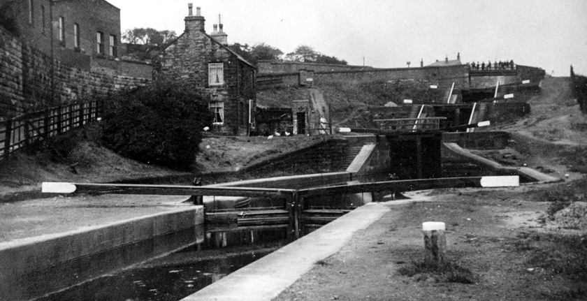
We went for a walk down most of the Wigan locks on the Leeds-Liverpool Canal on Boxing Day. I'd not checked for locations of benchmarks beforehand & spotted precisely zero!

Looking at the 1894 OS 25 inch map afterwards I counted 19 marks that we walked past the location of. Some will have disappeared - bridges widened, buildings demolished, etc. - but I thought I would have found at least one.
On Friday we took the grandchildren to see the (not as famous as I think it should be

)
Meccano Bridge at the head of Prestolee Locks on the old Manchester, Bolton & Bury Canal. Here I spotted one in the wall as we walked down next to the flight of locks. I've not found it marked on any maps I've looked at but it is in the OS database linked to earlier.
.jpg (414.79 KiB) Viewed 1263 times")
- Meccano Bridge (click to enlarge)
.jpg (471.46 KiB) Viewed 1263 times")
- Benchmark near locks (click to enlarge)
.jpg (434.74 KiB) Viewed 1263 times")
- Benchmark is in wall to left, Bridge is in distance on right (click to enlarge)
Manchester Bolton & Bury Canal Society have a similar photo, but taken from the other side of the channel showing the original bridge
(From
MB&BCS Key Facts page)
Re: OS bagging
Posted: 31 Mar 2019, 10:01pm
by Lance Dopestrong
Nice work Rick. I must pull my finger out and bag a few more.
Re: OS bagging
Posted: 25 Nov 2019, 11:13am
by gaz
It's a bit damp out. Remembered this thread whilst I was passing.
IMG_20191125_100711.jpg
viewtopic.php?f=15&t=22620&p=180585&#p180585
Re: OS bagging
Posted: 25 Nov 2019, 11:34am
by DNC123
[Anorak mode on]
How many on here know that Mean Sea level changed in 1921? Prior to that date it was measured from a mark in Victoria Dock Liverpool. After 1921 the measurement was taken from Newlyn in Cornwall and sea level is apparently different down there. Maybe it's to do with the curvature of the earth!!! Whatever all heights changed when the datum point was moved.
[/Anorak mode off]
Re: OS bagging
Posted: 25 Nov 2019, 12:51pm
by Cyril Haearn
We know that now, very good, else one should never have known of Newlyn
Sea level is expected to rise so mountains shall become lower
Re: OS bagging
Posted: 25 Nov 2019, 6:41pm
by arnsider
Ordnance Survey down graded the whole Trig Network when GPS became really accurate around the early nineties.
Before then, a colossal operation was undertaken to establish the network, with first order levelling and Theodolite observations.
Actually finding old marks can be a needle in haystack scenario, especially bench marks on walls.
I would not have thought the pursuit to be compatible with cycling bearing in mind the ferreting about required off the bike!
Re: OS bagging
Posted: 25 Nov 2019, 6:50pm
by arnsider
Newlyn observatory determined Mean Sea level over a long period.
Mean sea level is pretty dynamic and is subject to great variation, storm surges, tidal stream velocity etc.
OS levels were suppied predominantly for engineering purposes namely drainage and as such were adequate.
Geodetic considerations are a seperate field.
Re: OS bagging
Posted: 25 Nov 2019, 6:57pm
by arnsider
The flush brackets were designed to take a metal platform that had a foot at the same level as the arrow top.
The same accuracy could be achieved sitting the staff on a two bob coin, provided you allowed a few millimeters for the coin thickness.
I well remember closing a long line of obs on a bracket on a church near Droitwich. The sums misclosed by a couple of feet and I was crestfallen at the prospect of doing it all again.
I carried on to the next OSBM and hey presto, it closed within thirty millimeters. Some mason had moved the bracket up the wall a couple of courses!!!
Re: OS bagging
Posted: 28 Nov 2019, 1:11pm
by Will
arnsider wrote:Some mason had moved the bracket up the wall a couple of courses!!!
I've seen that before. Many years ago I was a Land Surveyor. One day we had to do a spot of levelling and went to the nearest BM to our site. It looked like the wall had been rebuilt. We closed on a couple of other BMs to verify. There was a new road being constructed next to our site and as we were packing up a Civil Engineer came over to warn us about the local BM. Apparently they had come off it without checking it. They had to make some 'adjustments' on the road construction in order to get it to meet in the middle

.
The National Library for Scotland Maps website (
https://maps.nls.uk/) has 1:1250 and 1:2500 maps that show BMs.
Will
Re: OS bagging
Posted: 6 Dec 2019, 12:24pm
by arnsider
LOL!!
Dare I say that the standards of Surveying and levelling practises among Civil Engineers leaves a lot to be desired.
Re: OS bagging
Posted: 12 Apr 2020, 11:07pm
by nick12
I know it's an old topic but came across this benchmark on hob moor near the knavesmire at York on Friday.
Re: OS bagging
Posted: 1 Jun 2020, 2:31pm
by gaz
gaz wrote:Took a detour today in search of a fundamental bench mark. Totally failed to find it

. ... I'll have another go sometime.
Sometime finally arrived.
IMG_20200601_104840.jpg
Re: OS bagging
Posted: 1 Jun 2020, 3:30pm
by simonineaston
You've all doubtless heard of Trig Points and know what they are? There's a thriving hobby among walkers, but also cyclists too, of trying to 'bag' (ie, visit) as many as possible.
I tried Geocaching briefly, before I realised that a solo middle-aged man, poking around in undergrowth, muttering, in places where family groups enjoy leisure is not a good look...

Re: OS bagging
Posted: 3 Jun 2020, 9:18pm
by gaz
Flush bracket yesterday.
IMG_20200602_104506.jpg
Re: OS bagging
Posted: 3 Jun 2020, 9:50pm
by rjb
gaz wrote:Flush bracket yesterday.
I'm now an expert on such matters, just installed 2 dual flush valves today while it was raining.