What a great response! That is what I call service!
Cycle Travel Question
-
pedalsheep
/sheep.jpg)
- Posts: 1324
- Joined: 11 Aug 2009, 7:57pm
Re: Cycle Travel Question
'Why cycling for joy is not the most popular pastime on earth is still a mystery to me.'
Frank J Urry, Salute to Cycling, 1956.
Frank J Urry, Salute to Cycling, 1956.
-
BeardyWeirdy
- Posts: 58
- Joined: 10 Jul 2007, 10:49am
Re: Cycle Travel Question
Thanks Richard - very handy

Re: Cycle Travel Question
It would be nice if the sort options in map view were sticky so, if you go to a route & then back to the map, they stay sorted in the same order as before.
Also the profile option to use "miles & feet" seems to heights in metres, the same as the "miles & metres" option. A profile option to make routes private by default would be good too (for works in progress & routes starting/finishing from home. Many of mine are one or the other).
None of these are "biggies" or urgent & all the work you do on this is much appreciated.
Former member of the Cult of the Polystyrene Head Carbuncle.

Re: Cycle Travel Question
Richard, have you been spending lock downs and cold winters evenings uploading more European cycle routes onto cycle.travel? I’m sure there are more each time I look.
Loving using it to plan some trips this year.
Loving using it to plan some trips this year.
Re: Cycle Travel Question
Hi Richard. I have a general question (with some specific applications...). There are some cycle paths which cycle.travel counts as 'paved', but aren't. Mostly, these are fine (because the surface is good enough to be navigable on a road bike), but there are a few where the surface is really quite poor. I recall you saying that cycle.travel makes use of OSM info to assess the quality of road surfaces -- but, having looked at OSM, I'm not sure where that info is stored, or how to amend it: do you have advice on how best to do this? (I'm v. much an OSM novice, I have to confess.)
(The specific instance I have in mind is the stretch of 'Hart to Haswell' cycle path, part of NCN1 in County Durham, from Haswell south to about Shotton Colliery, which can be almost uncycleable, esp. in winter, but which cycle.travel offers as a 'paved' route. But there are occasionally other times where cycle.travel routes down a path which is quite hard to cycle, so it would be useful to know how to log these. nb I know this isn't your fault -- rather the fault of whoever it is round here (Sustrans? Durham County Council?) who's happy to label the most terrible bits of sub-single-track path as cycleways!)
(The specific instance I have in mind is the stretch of 'Hart to Haswell' cycle path, part of NCN1 in County Durham, from Haswell south to about Shotton Colliery, which can be almost uncycleable, esp. in winter, but which cycle.travel offers as a 'paved' route. But there are occasionally other times where cycle.travel routes down a path which is quite hard to cycle, so it would be useful to know how to log these. nb I know this isn't your fault -- rather the fault of whoever it is round here (Sustrans? Durham County Council?) who's happy to label the most terrible bits of sub-single-track path as cycleways!)

Re: Cycle Travel Question
In OSM, click on the "query features" button, and then on the map item you want to find out about
You'll get each feature at the click location listed on the left, and you can click on one to see the properties.
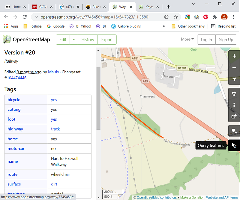
IIRC, cycle.travel looks at the "surface" tag when deciding on routing, though it may be the "tracktype" tag.
Clicking on the tag name will list the values for it - e.g. https://wiki.openstreetmap.org/wiki/Key:surface
You've got to register,log in & learn how to edit to change the tags, but there's an "add note" button just above the query feature button that you can use without, and hopefully an editor will see the note and make the change for you.
You'll get each feature at the click location listed on the left, and you can click on one to see the properties.
IIRC, cycle.travel looks at the "surface" tag when deciding on routing, though it may be the "tracktype" tag.
Clicking on the tag name will list the values for it - e.g. https://wiki.openstreetmap.org/wiki/Key:surface
You've got to register,log in & learn how to edit to change the tags, but there's an "add note" button just above the query feature button that you can use without, and hopefully an editor will see the note and make the change for you.
Last edited by andrew_s on 26 Jan 2022, 10:37pm, edited 1 time in total.
Re: Cycle Travel Question
Be nice if OSM ever get the side buttons to work in Safari! They've been not working for ages now, reported ages ago. Problem apparently down to a bug in Leaflet Maps and when OSM updated the version they use they didn't test it properly so quite a few people lost a lot of functionality (not just "Query Features" but more commonly used things like what layers are displayed. Major failure of OSM's software.andrew_s wrote: ↑26 Jan 2022, 10:14pm In OSM, click on the "query features" button, and then on the map item you want to find out about
You'll get each feature at the click location listed on the left, and you can click on one to see the properties.
IIRC, cycle.travel looks at the "surface" tag when deciding on routing, though it may be the "tracktype" tag.
Clicking on the tag name will list the values for it - e.g. https://wiki.openstreetmap.org/wiki/Key:surface
You've got to register & learn how to change the tags, but there's an "add note" button just above the query feature button that you can use without, and hopefully an editor will see the note and make the change for you.
Ian
Re: Cycle Travel Question
Thanks -- this is v. helpful! I'll give it a go...andrew_s wrote: ↑26 Jan 2022, 10:14pm In OSM, click on the "query features" button, and then on the map item you want to find out about
You'll get each feature at the click location listed on the left, and you can click on one to see the properties.
...
IIRC, cycle.travel looks at the "surface" tag when deciding on routing, though it may be the "tracktype" tag.
Clicking on the tag name will list the values for it - e.g. https://wiki.openstreetmap.org/wiki/Key:surface
You've got to register,log in & learn how to edit to change the tags, but there's an "add note" button just above the query feature button that you can use without, and hopefully an editor will see the note and make the change for you.
(Edited to add: I went back to OSM to check, and as far as I can see, the specific bit of path I have in mind has no 'surface' tag at all -- I guess that might be what's causing the glitch for cycle.travel? Anyway: I've added a note -- thanks for the advice!)
Last edited by pal on 27 Jan 2022, 11:43am, edited 1 time in total.
-
Richard Fairhurst
- Posts: 2035
- Joined: 2 Mar 2008, 4:57pm
- Location: Charlbury, Oxfordshire
Re: Cycle Travel Question
cycle.travel does indeed take its base map information from OSM, including surface data.pal wrote: ↑25 Jan 2022, 11:39am Hi Richard. I have a general question (with some specific applications...). There are some cycle paths which cycle.travel counts as 'paved', but aren't. Mostly, these are fine (because the surface is good enough to be navigable on a road bike), but there are a few where the surface is really quite poor. I recall you saying that cycle.travel makes use of OSM info to assess the quality of road surfaces -- but, having looked at OSM, I'm not sure where that info is stored, or how to amend it: do you have advice on how best to do this? (I'm v. much an OSM novice, I have to confess.)
(The specific instance I have in mind is the stretch of 'Hart to Haswell' cycle path, part of NCN1 in County Durham, from Haswell south to about Shotton Colliery, which can be almost uncycleable, esp. in winter, but which cycle.travel offers as a 'paved' route. But there are occasionally other times where cycle.travel routes down a path which is quite hard to cycle, so it would be useful to know how to log these. nb I know this isn't your fault -- rather the fault of whoever it is round here (Sustrans? Durham County Council?) who's happy to label the most terrible bits of sub-single-track path as cycleways!)
It looks like the Hart to Haswell Walkway is just mapped as a "cycleway" in OSM without any surface information. In the absence of any other information, cycle.travel is assuming it's paved. So the trick is to add surface information so that cycle.travel will know next time it takes an update from OSM.
Roughly speaking you do that like this:
- register an account on OSM
- go to the right place on the map (https://www.openstreetmap.org/#map=18/54.79164/-1.40451)
- click "Edit"
- when the map editor appears, click to select the cycle path in question
- on the left, in the dropdown under Surface, change it to "Gravel" (or one of the other values that appears in the menu)
- repeat for all other segments of the cycle path - a cycle path will typically be broken up into several segments ("ways") in OSM and you'll need to do this for each one
- when you've finished, click "Save" at the top right
cycle.travel - maps, journey-planner, route guides and city guides
Re: Cycle Travel Question
Thanks, Richard! That sounds like an excellent procrastination activity -- I will save it up for next time I have a big pile of marking to do 
(And thanks for everything you do on cycle.travel: I am somewhere between a superfan and an addict...)
(And thanks for everything you do on cycle.travel: I am somewhere between a superfan and an addict...)
-
chris_suffolk

- Posts: 738
- Joined: 18 Oct 2012, 10:01pm
Re: Cycle Travel Question
May already have been answered above, but can I get cycle.travel to create a route betweem 2 points, on a public road, that it just won't link?
The area is Nenthead in Yorks, specially (54.7887, -23412) to (54.7883, -23409). Only about 100 yards apart, on a public road but it just won't lt me use that section for some reason.
Ideas?
The area is Nenthead in Yorks, specially (54.7887, -23412) to (54.7883, -23409). Only about 100 yards apart, on a public road but it just won't lt me use that section for some reason.
Ideas?
-
Richard Fairhurst
- Posts: 2035
- Joined: 2 Mar 2008, 4:57pm
- Location: Charlbury, Oxfordshire
Re: Cycle Travel Question
It's a cobbled road - at present cycle.travel won't route along cobbled roads if you've set it to "Paved only". If you change to "Any surface" it should be happy.
cycle.travel - maps, journey-planner, route guides and city guides

Re: Cycle Travel Question
Ahemchris_suffolk wrote: ↑2 Feb 2022, 11:49am May already have been answered above, but can I get cycle.travel to create a route betweem 2 points, on a public road, that it just won't link?
The area is Nenthead in Yorks, specially (54.7887, -23412) to (54.7883, -23409). Only about 100 yards apart, on a public road but it just won't lt me use that section for some reason.
Ideas?
Be sure to use the cafe at the bottom.
Whatever I am, wherever I am, this is me. This is my life
https://stcleve.wordpress.com/category/lejog/
E2E info
https://stcleve.wordpress.com/category/lejog/
E2E info

Re: Cycle Travel Question
Apologies if asked before.
Is it possible to force a tablet (android) to go to the normal desktop layout?
On my tab it is now different and the "round trip" button isn't available top leftish.
There is a drop down menu on the right of the screen with a whole load of functions there. But I can't see "round trip" amongst them. In fact I can't see the whole list at all as it drops off the bottom and I can see no way of scrolling the list up to see the missing items.
Sweep
Re: Cycle Travel Question
There are different types of tablet each having different types of browser available. More details of your configuration? e.g. on iPad with Safari your can do "Request desktop ..."Sweep wrote: ↑12 Feb 2022, 2:09pm Apologies if asked before.
Is it possible to force a tablet (android) to go to the normal desktop layout?
On my tab it is now different and the "round trip" button isn't available top leftish.
There is a drop down menu on the right of the screen with a whole load of functions there. But I can't see "round trip" amongst them. In fact I can't see the whole list at all as it drops off the bottom and I can see no way of scrolling the list up to see the missing items.
Ian